Komodo Island Map
Komodo National Park has widely known with the home of the giant lizard Komodo Dragon – which has just declare to be one of the latest heritage of the world. This is the home of the giants lizard known as the Komodo Dragon it was thought to be a myth until the turn of the century, when fishermen who were forced by a storm to take shelter on Komodo sight the monsters
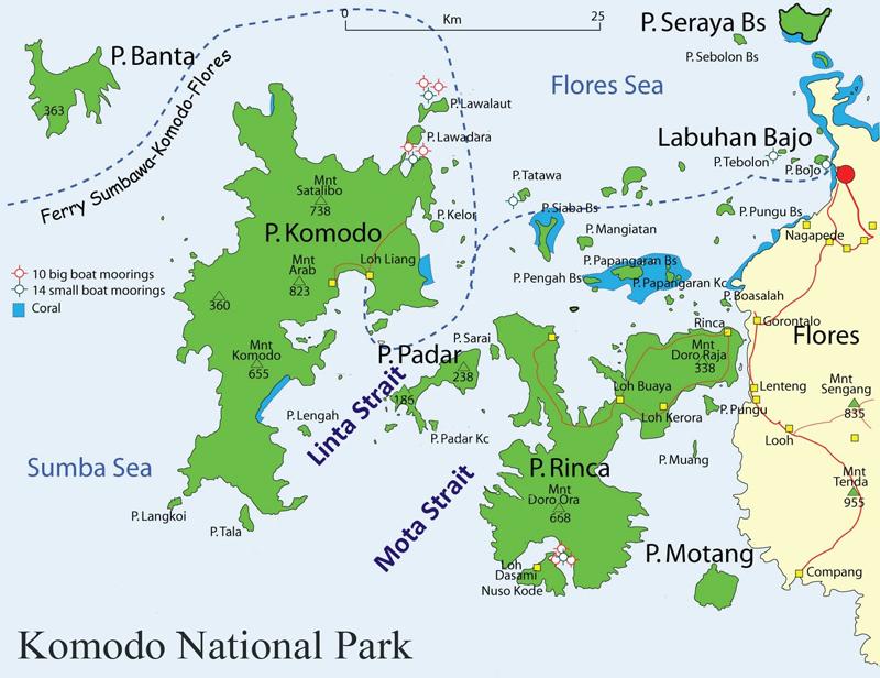
Komodo National Park lies in the Wallacea Region of Indonesia. The Park is located between the islands of Sumbawa and Flores at the border of the Nusa Tenggara Timur (NTT) and Nusa Tenggara Barat (NTB) provinces.
It includes three major islands, Komodo, Rinca and Padar, and numerous smaller islands together totaling 603 km2 of land. The total size of Komodo National Park is presently 1,817 km2. Proposed extensions of 25 km2 of land (Banta Island) and 479 km2 of marine waters would bring the total surface area up to 2,321 km2
Komodo National Park was established in 1980 and was declared a World Heritage Site and a Man and Biosphere Reserve by UNESCO in 1986. The park was initially established to conserve the unique Komodo dragon (Varanus komodoensis), first discovered by the scientific world in 1911 by J.K.H. Van Steyn. Since then conservation goals have expanded to protecting its entire biodiversity, both marine and terrestrial.
The majority of the people in and around the Park are fishermen originally from Bima (Sumbawa), Manggarai, South Flores, and South Sulawesi. Those from South Sulawesi are from the Suku Bajau or Bugis ethnic groups. The Suku Bajau were originally nomadic and moved from location to location in the region of Sulawesi, Nusa Tenggara and Maluku, to make their livelihoods. Descendents of the original people of Komodo, the Ata Modo, still live in Komodo, but there are no pure blood people left and their culture and language is slowly being integrated with the recent migrants.
Little is known of the early history of the Komodo islanders. They were subjects of the Sultanate of Bima, although the islands remoteness from Bima meant its affairs were probably little troubled by the Sultanate other than by occasional demand for tribute.
Topography: The topography is varied, with slopes from 0 – 80%. There is little flat ground, and that is generally located near the beach. The altitude varies from sea level to 735 m above sea level. The highest peak is Gunung Satalibo on Komodo Island.
Komodo Island Map
Geology: The islands in Komodo National Park are volcanic in origin. The area is at the juncture of two continental plates: Sahul and Sunda. The friction of these two plates has led to large volcanic eruptions and caused the up-thrusting of coral reefs. Although there are no active volcanoes in the park, tremors from Gili Banta (last eruption 1957) and Gunung Sangeang Api (last eruption 1996) are common. West Komodo probably formed during the Jurasic era approximately 130 million years ago. East Komodo, Rinca, and Padar probably formed approximately 49 million years ago during the Eocene era.